

Project Overview
This tutorial describes the process of creating a 3D infrastructure and landscape scene from an AutoCAD design drawing using MAX/VIZ and Key 3D application software
Firstly, surfaces are created from an accurate landform mesh made from 2D and 3D polylines using Key 3D surfacing routines. This method suits most hard and soft infrastructure and landscape schemes when edges for roads, pavements, paths and soft landscaping and other hard surfaces need to be accurately defined. The process can also compliment other systems for generating 3D infrastructure (3D highways design software such as Moss, Civil 3D or Key Terra-Firma), giving a more complete and detailed set of tools for dealing with the landscape as a whole.
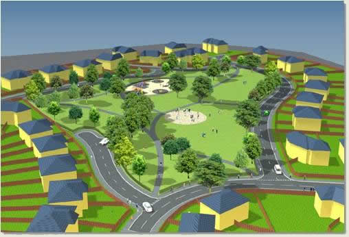
The resulting "spline model" is optimised before using it as the building block for a complete landform mesh. Surfaces are defined using 2D closed and seamless boundaries drawn in AutoCAD and these boundaries are used to cut and create new surfaces out of the landform mesh for all hard and soft surfaces using Key 3D Surfaces routine. Lamp posts and trees are automatically replaced from AutoCAD blocks using Key 3D Model Objects and Key 3D Image Objects dialogs and Key 3D Material Tiler is used to quickly apply paving and grass textures to the surfaces. Sky backgrounds and sunlight and shadow properties are adjusted using Key 3D Sky and Key 3D Sunlight and Shadows routines and views created and managed using the Key 3D View Manager. Other invaluable Key 3D tools are used along the way to create an accurate 3D scene for many modern presentation purposes
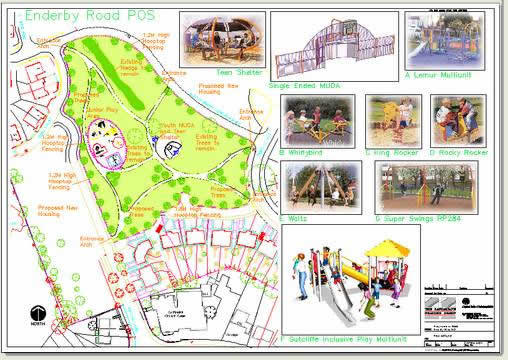
The data used in this tutorial has been supplied by Birmingham City Council Landscape Practice Group
Donate to CADTutor
If you found this tutorial useful, you might like to consider making a donation. All content on this site is provided free of charge and we hope to keep it that way. However, running a site like CADTutor does cost money and you can help to improve the service and to guarantee its future by donating a small amount. We guess that you probably wouldn't miss $5.00 but it would make all the difference to us.
Local Navigation
Sponsored Links

The Basics
- Dual Dimensions in a Dim…
- UCSICON Options
- "Best of" Basics: Irreg…
- Tool Palette Basics
- Original Dimension Value
- Possible Solutions to th…
- Avoid Using 'Standard' i…
- Shorten the Plot Scales…
- Update the Source File B…
- User Increment Angles fo…
- Drawing Information
- 'Sign Language'
- Rotate with the Copy Opt…
- Use the INSERT Osnap on…
- To or From the Current L…


